免职声明:本网站为公益性网站,部分信息来自网络,如果涉及贵网站的知识产权,请及时反馈,我们承诺第一时间删除!
This website is a public welfare website, part of the information from the Internet, if it involves the intellectual property rights of your website, please timely feedback, we promise to delete the first time.
电话Tel: 13002979178 OR 邮箱Email: Lngbbs@qq.com
摘要:截至6月4日,大庆钻探自研的录井水淹层智能解释评价模型已平稳运行一周。作为国内首创的水淹层智能解释评价模型,该模型可精准识别专业地质图像资料,实现数秒判识水淹等级,作业效率提升超80%。
|
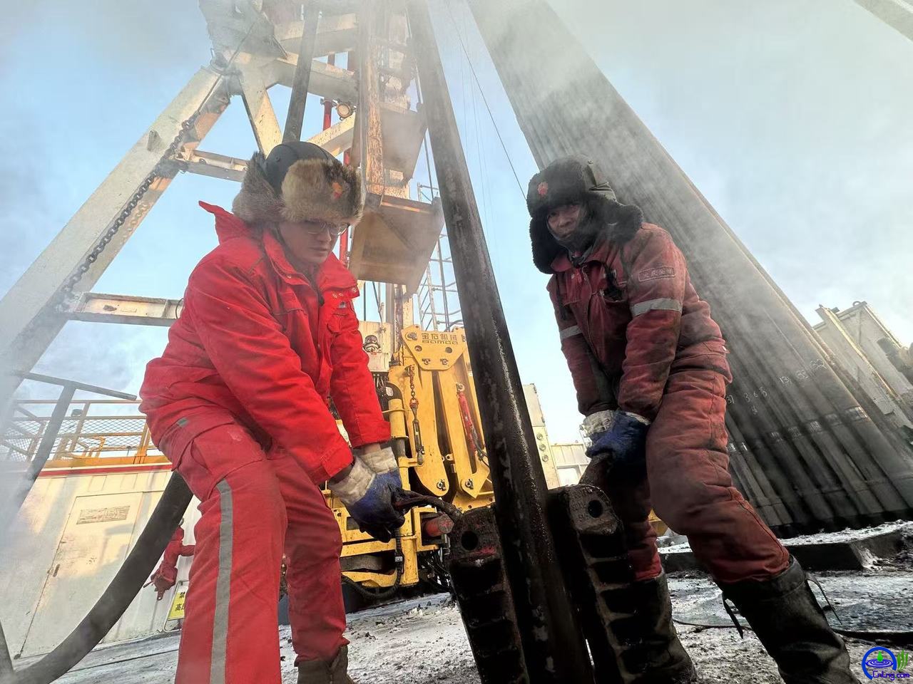
中国石油网消息:截至6月4日,大庆钻探自研的录井水淹层智能解释评价模型已平稳运行一周。作为国内首创的水淹层智能解释评价模型,该模型可精准识别专业地质图像资料,实现数秒判识水淹等级,作业效率提升超80%。 China Oil News: As of June 4th, the intelligent interpretation and eva luation model for water-flooded layers independently developed by Daqing Drilling has been running smoothly for one week. As the first of its kind in China, this model can accurately identify professional geological image data and determine the water-flooded level within seconds, with the operational efficiency increasing by over 80%. 随着油田进入开发中后期,水淹层广泛发育、分布零散,油气精细挖潜难度持续增大。为盘活剩余油藏资源,助力油田稳产上产,大庆钻探以科技钻探建设为契机,聚焦水淹层精细解释核心业务,开展智能技术攻关,为油气高效挖潜和精细开发装上强劲的“智能大脑”。 As the oilfield enters the middle and late stages of development, water-flooded layers are widely distributed and scattered. The difficulty of conducting detailed exploration and exploitation of oil and gas resources continues to increase. To revitalize the remaining reservoir resources and contribute to the stable and increased production of the oilfield, Daqing Drilling took the opportunity of technological drilling construction, focused on the core business of detailed interpretation of water-flooded layers, carried out intelligent technology research and development, and equipped the oil and gas efficient exploitation and detailed development with a powerful "intelligent brain". “过去水淹层解释评价基本依赖技术人员,研判结果受主观经验影响,耗时长、效率低。”模型项目负责人左铁秋坦言,遇到复杂储层需反复比对分析,流程烦琐、标准难以统一,制约了录井解释工作的质量和效率。 "Previously, the interpretation and eva luation of water-saturated layers relied mainly on technicians. The judgment results were influenced by subjective experience, and the process was time-consuming and inefficient." Project leader Zuo Tieqiu admitted that when dealing with complex reservoirs, repeated comparisons and analyses were required, and the process was cumbersome and the standards were difficult to unify, which hindered the quality and efficiency of logging interpretation work. 为补齐人工研判短板,大庆钻探研发团队将AI专项算法与水淹层专业评价技术深度融合。“我们耗时一年,系统梳理并标注了20余年积累的3000多口井20万余条地质资料,全面复盘过往的业务成果,再手把手训练并优化模型。”左铁秋说,以往人工研判单井耗时近1小时,如今借助智能模型,10分钟内即可高效完成。 To address the shortcomings of manual analysis, the research and development team of Daqing Drilling has deeply integrated the AI-specific algorithms with the professional eva luation technology for waterlogged layers. "We spent one year systematically sorting out and annotating over 30,000 pieces of geological data from more than 2,000 wells accumulated over 20 years. We comprehensively reviewed the past business achievements, and then trained and optimized the model step by step," said Zuo Tieqiu. Previously, it took nearly one hour to analyze a single well manually. Now, with the help of the intelligent model, the task can be completed efficiently within 10 minutes. “模型不仅提效明显,还新增专业谱图、荧光图像智能识别功能。”项目技术骨干孙秋霞介绍道。技术人员将10张地质图像图表上传后,模型在2分钟内可快速解析图表信息并自动生成分析报告。相较于传统模型,该模型可专业化、高精度识别录井图像资料,高效完成水淹层智能评价工作,有效提升了技术服务质量与作业效率。 "The model not only significantly improves efficiency, but also adds professional spectrogram and fluorescence image intelligent recognition functions." Project technical expert Sun Qiuxia explained. After the technicians uploaded 10 geological image charts, the model could quickly analyze the chart information and automatically generate an analysis report within 2 minutes. Compared with traditional models, this model can professionally and accurately identify logging image data, efficiently complete the intelligent eva luation of waterlogged layers, and effectively improve the technical service quality and operation efficiency. 为保障模型专业精准度,研发团队把资深地质专家数十年现场识图判层的实战经验,转化为颜色、亮度、孔隙结构等量化判别标准,让模型练就精准识图、参数提取、解释评价的专业能力。 To ensure the professional accuracy of the model, the R&D team transformed the practical experience of senior geological experts in on-site image recognition and layer classification over several decades into quantitative criteria such as color, brightness, and pore structure, enabling the model to acquire the professional capabilities of accurate image recognition, parameter extraction, and interpretation and eva luation. 目前,研发团队正持续迭代优化模型,计划将这套“会看图、懂专业、能研判”的智能体系,拓展到岩性归位、综合解释、工程预警等录井全业务链条,以数智化科技创新助力科技钻探、数字钻探高质量发展。 Currently, the R&D team is continuously iterating and optimizing the model. They plan to expand this intelligent system, which is capable of "understanding images, comprehending specialties, and making judgments", to the entire logging business chain including lithology positioning, comprehensive interpretation, and engineering early warning. This will be achieved through digital and intelligent technological innovation to support the high-quality development of scientific drilling and digital drilling. |